Equinox satellite systems

Military-Grade Surveillance
for Sovereign Intelligence

Argus-VHR
Arugus-HR

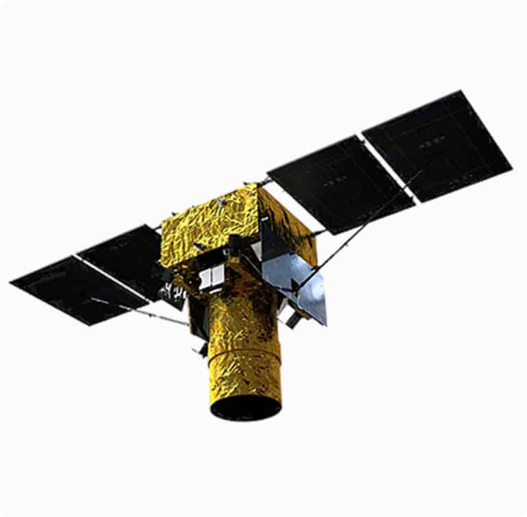
Argus-VHR (0.3m Resolution)

(availability is subject to export permits of optical payload components)
Key Defense Features

Tactical-Grade Imagery

  • 0.5m PAN / 2m MS resolution (530km orbit) – ID vehicles, artillery, and small infrastructure
  • 12km swath width with pushbroom TDI for wide-area mapping of conflict zones

Battlefield-Ready Payload

  • CCD array with 11-bit quantization – Enhanced contrast for low-light/NIR surveillance
  • 700,000 km² daily coverage – Monitor entire border regions in <24hrs
  • 2TB onboard storage – Secure data retention during comms blackouts

Multi-Mode Targeting

  • Nadir/rolling/stereo imaging – Track moving convoys or missile launchers
  • DEM production – Terrain mapping for special ops infiltration planning
Defense Benefits
Precision Strike Support
Detect <1m targets for drone/UAV targeting
Denied-Area Intel
NIR spectrum (0.77–0.89µm) reveals camouflaged positions
Rapid Revisit
Sun-synchronous orbit (530km) enables 4+ passes/day over hotspots

Argus-HR (0.5m Resolution)

Key Defense Features

High-Speed Recon

  • 0.5m full-color / 1m MS resolution (500km orbit) – Identify weapon systems and troop movements
  • 15km swath – Balance detail and area coverage for tactical awareness

Low-Power Stealth

  • 305W operation – Reduced thermal signature vs. competitors
  • 40dB SNR – Clear imaging through dust/smoke (e.g., wildfire camouflage)

All-Weather Capability

  • 450–900nm spectrum – Day/night ops with NIR penetration
  • <7% radiometric error – Reliable change detection for base monitoring
Defense Benefits
Precision Strike Support
Detect <1m targets for drone/UAV targeting
Denied-Area Intel
NIR spectrum (0.77–0.89µm) reveals camouflaged positions
Rapid Revisit
Sun-synchronous orbit (530km) enables 4+ passes/day over hotspots
System Values

Argus Constellation Advantages

Capability Argus-VHR (0.3m) Argus-HR (0.5m) Commercial Competitors
Resolution 0.5m PAN (tactical ID) 0.5m color (force tracking) 1m+ (WorldView-4)
Swath Speed 12km@ 700k km²/day 15km@ 300k km²/day 8–10km (Maxar)
Spectrum PAN+NIR (camouflage defeat) Blue-NIR (all-weather) RGB only
Deployment Time 12-18 months (AIT) 9-12 months (AIT) Available only to US client states
Sovereignty ITAR-free, client-owned ground ITAR-free, AI-driven analytics U.S. data restrictions
Utility Instance

Defense Use Cases

Border Security
  • Detect illegal crossings/terrorist infiltration with 0.5m resolution
  • Monitor adversarial troop buildups in near-real-time
Target Acquisition
  • Provide coordinates for precision strikes (CEPs <3m)
  • Post-strike damage assessment via change detection
Maritime Domain Awareness
  • Track naval movements (identify ship classes via 8.75µm pixels)
  • Spot smuggler vessels disguised as fishing boats
Critical Infrastructure Protection
  • Monitor nuclear/energy sites for sabotage attempts
  • Map terrain for base defense planning
Key Points

Argus: Eyes in Orbit for Unmatched Tactical Dominance

See first, strike first
Resolve <1m targets with sovereign satellites
No data-sharing
Your imagery never transits adversarial clouds
Defeat camouflage
NIR spectrum reveals what enemies hide
Deploy your Argus optical constellation in 12 months
Request specifications
Competitive Advantages

Differentiators vs. U.S./Israeli/
European Systems

No ITAR
Detect illegal crossings/terrorist infiltration with 0.5m resolution
AI Analytics
Onboard processing flags suspicious activity (e.g., SAM site construction)
Hybrid Constellations
Pair with NEXORBIT comms satellites for sensor-to-shooter links